

Hurricane Beryl tracker: Landfall in Texas next week looking more likely

When will Hurricane Beryl hit Texas?
New models show that Hurricane Beryl is likely to make landfall in Texas next week. FOX 4 meteorologist Kylie Capps takes a look at the storm's path and the possible impact it could have on North Texas.
Hurricane Beryl, now a Category 2, continues to move west, and it is looking more likely that it will make landfall in Texas next week.
On Thursday morning, the hurricane impacted the Cayman Islands with winds of 120 miles per hour.
It made landfall again with 110 mph winds near the popular tourist area of Tulum, Mexico on Friday morning.
After leaving the Yucatán, Beryl is expected to move along the southern Gulf of Mexico where it is expected to gain strength.
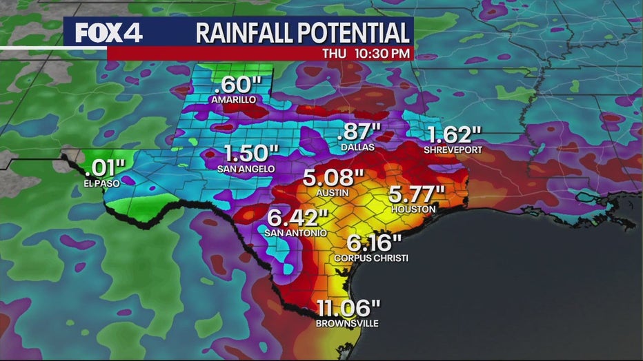
At this point, it does look like Sunday night or early Monday morning Beryl will make landfall south of Brownsville, on the Texas-Mexico border.
READ MORE: NOAA issues its most aggressive hurricane season forecast on record
What happens after that is still in question. Long range models are hinting at Beryl moving to the north and impacting parts of central and possibly even North Texas.

Hurricane Beryl: 9 killed in Caribbean
Hurricane Beryl is being blamed for 9 deaths in the Caribbean and now the storm sets its sights on a popular tourist destination in Mexico.
The main impact of Beryl is expected to be in south and southeast Texas in the early parts of next week.
Brownsville could see close to a foot of rain.
Texas Governor Greg Abbott directed the Texas Division of Emergency Management to increase the increase the readiness level of the State Emergency Operations Center to Level II effective at 10 a.m. on Friday.
That means state resources will be ready for deployment as Beryl approaches.
We will keep watching and updating our forecast as we get closer to Monday.