

Dallas weather: Storms hit North Texas as Severe Thunderstorm Watch issued for the region
LIVE UPDATES
10 p.m.: Viewer photos show incredible lightning strikes from storms
9:30 p.m.: David Sentendrey details severe weather across region
DALLAS - FOX 4 reporter David Sentendrey has been driving around North Texas throughout tonight's severe weather. He detailed some of the damage he saw in the video below.

Heavy rain causes damage across Dallas County, North Texas
A severe set of storms hit North Texas on Wednesday, causing building damage and flooding across Dallas County and other areas. FOX 4's David Sentendrey has been on the road and gives updates on what he's seen.
Sentendrey notes severe flooding in Alvarado, a building in Garland whose roof collapsed, and heavy rainfall across his travels.
9:10 p.m.: Severe Thunderstorm Warning issued for more counties
Van Zandt County is now under a Severe Thunderstorm Warning until 9:45 p.m., while Parker County is under the same until 9:30 p.m.
9 p.m.: Heavy rainfall continues to pelt North Texas
The Severe Thunderstorm Warnings have ended, but a Severe Thunderstorm Watch and Flash Flood Warnings still hang over most of North Texas. Below is a look at total rainfall for the last few hours.

8:30 p.m.: Send us your pictures and videos of today's storm!
8:15 p.m.: Intense supercell seen above Rockwall
This image was sent in by viewer Stacey Romo in Rockwall, where you can see a hail-producing supercell formed above the city.

7:45 p.m.: Quarter-sized hail reported south of DFW metroplex
A storm in Johnson County near Parker is showing radar indications of producing nickel to quarter-sized hail between Grandview and Rio Vista along FM 916 and FM 4.

7:30 p.m.: FOX 4 chief meteorologist Dan Henry weather briefing on North Texas severe weather
Tuesday weather briefing as thunderstorms hit North Texas
A Severe Thunderstorm Watch has been issued for most of North Texas, with Severe Thunderstorm Warnings affecting several counties. FOX 4 chief meteorologist Dan Henry has more in this weather briefing.
Henry reports that flash flooding has been reported in southern Dallas County, including DeSoto.
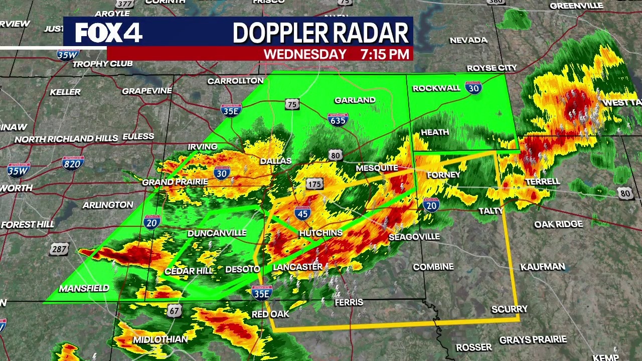
7:15 p.m.: More warnings issued
A Severe Thunderstorm Warning was issued for areas near Dallas County, TX, Ellis County, TX and Kaufman County, TX from March 4 at 7:12 p.m. until 8:15 p.m.
6:15 p.m.: Another Severe Thunderstorm Warning issued for North Texas
Another Severe Thunderstorm Warning has been issued in North Texas for Tarrant County and Dallas County.
The Warning begins at 6:15 p.m. and ends at 7:15 p.m.

6 p.m. Garland roof collapse

Photo courtesy Ashley Trail
Police and firefighters responded to reports of a roof collapse on Kingsley Road near Industrial Lane in Garland around 6 p.m.
Officials confirmed it was a weather-related incident. The collapse was due to a buildup of water on the roof.
No one was hurt.
5:45 p.m.: Flash Flood Warning issued
A Flash Flood Warning has been issued for Tarrant County, Dallas County and Rockwall County, beginning at 5:35 p.m. and ending at 8 p.m.

The National Weather Service says there is a significant threat to life in the affected counties.
5:10 p.m.: Severe Thunderstorm Warning issued for several North Texas counties
A Severe Thunderstorm Warning has been issued for Dallas County and Tarrant County beginning at 5:10 p.m. and lasting until 6 p.m.

The system will move through areas of North Texas ranging from Lakeland Heights, Irving and Euless across the 5 p.m. hour. 1-inch hail and wind speeds of up to 60mph could be possible.
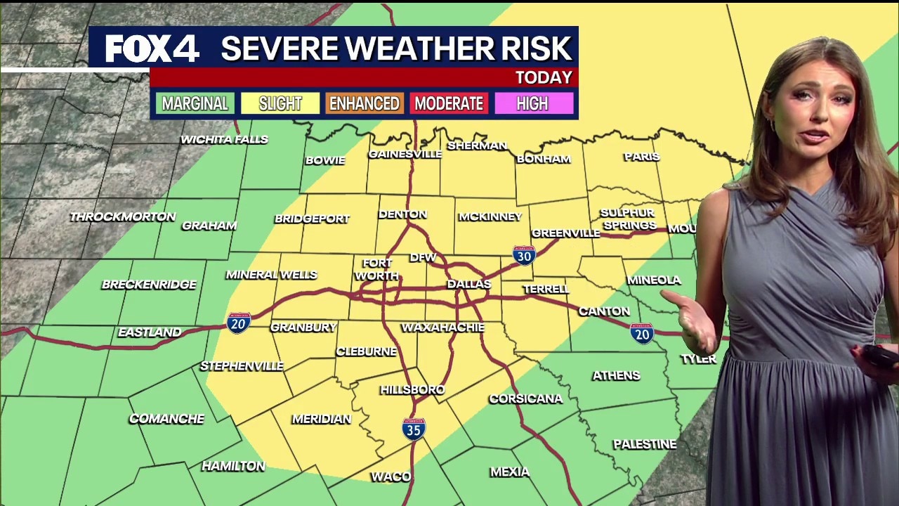
4:40 p.m.: Severe Thunderstorm Watch issued
The National Weather service issued a Severe Thunderstorm Watch for many parts of North Texas from 4:40 p.m. to 11 p.m. on Wednesday afternoon.

The National Weather Service says there is a significant threat to property or life in Hunt County, Somervell County, Rains County, Collin County, Fannin County, Rockwall County, Kaufman County, Denton County, Red River County, Johnson County, Tarrant County, Ellis County, Dallas County, Hood County, Parker County, Cooke County, Lamar County, Wise County, Hopkins County, Delta County.
Wednesday Forecast: Storms Arrive
Dallas Weather: March 4 noon forecast
FOX 4 Weather Meteorologist Kylie Capps gives an update on possible severe storms in the forecast for North Texas on Wednesday night.
Wednesday morning will remain mostly quiet with a 20% chance of light rain. But, a stalled front over North Texas is expected to spark strong to severe storms tonight. The primary window for activity is between 4 p.m. and 2 a.m.
The main concerns for Wednesday are wind gusts between 50 and 60 mph and hail roughly the size of quarters. While the tornado potential remains low, it cannot be ruled out. Some isolated gusts could reach up to 65 mph.
LIVE Radar: Dallas-Fort Worth

Thursday & Friday Forecast: Severe Threats Continue
Expect a lull in activity for much of Thursday and Friday, with only scattered showers in the forecast. Storm coverage and intensity will increase significantly Friday night as a stronger cold front moves into the region, bringing another round of severe weather.
A few storms remain possible Thursday, mainly west of the I-35 corridor, with the potential for small hail and gusty winds.

Weekend Forecast: Flooding and Severe Threats
Thunderstorm activity will intensify Friday, with large hail, damaging winds and a few tornadoes possible across North Texas.
By Saturday, the focus shifts to a rising flood threat. Heavy rain will fall on already saturated soil, increasing the risk of flash flooding. While rain chances remain in the forecast, the exact impact of next week’s precipitation is still being monitored.
Temperatures will stay warm through the end of the week, with mornings in the 60s and afternoon highs reaching the 70s and 80s. Saturday's cold front will eventually drop temperatures into the 50s at night, with afternoon highs in the 60s and low 70s through Sunday.
7-Day Forecast

The National Weather Service notes that flooding potential will likely increase over the weekend due to multiple rounds of heavy rain. Total rainfall amounts are expected to average between 1 and 3 inches from Friday through Monday, though some areas could see higher totals.
There is a secondary potential for severe weather on Tuesday, but confidence in that system remains low at this time.
The Source: Information in this article comes from FOX 4 forecasters and the National Weather Service.