

Dallas weather: Warm Saturday before temps tumble. Will we see ice next week?
Dallas weather: Feb. 15 morning forecast
FOX 4 meteorologist Kylie Capps takes a look at the mild weather across North Texas on Saturday and the upcoming drop in temperatures, including a chance for ice.
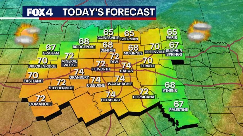
DALLAS - Saturday will be a warm day before the winter chill returns, including a shot at some ice on the roads next week.
Saturday Forecast: Warm early, cooler late
Timeline:
It's far from a perfect day as we start with low clouds and fog thanks to the return of Gulf moisture. Depending on where you live, that will clear west this morning, for the DFW area the clearing will happen in the late morning to noon and our eastern areas will see sun in the early afternoon. South breezes will shift to the southwest and the few hours with sun this afternoon will push temps to near 70 degrees. Don't get too used to it.
The next strong cold front will race down late afternoon, meaning after 4pm for most, but earlier north and later to the east and south. Like last week, winds will shift and get very gusty and temperatures will tumble into the 40s before sunset in many areas. There's a low chance for a shower on the front to the east of DFW as well.
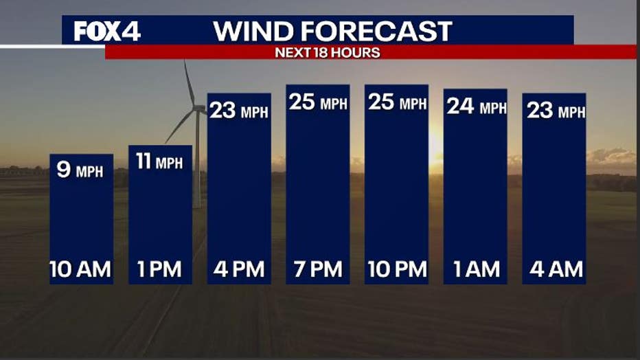
Tonight is windy and cold.
Sunday Forecast: Chilly Day
Timeline:
Temperatures will bottom out below freezing by morning, but not by more than a couple of degrees.
Wind chills Sunday morning will be in the teens. At least it will be a mostly sunny day as winds diminish in the afternoon to evening and we return to the 40s.
Monday Forecast: Freezing start to President's Day
Timeline:
For the most part, President's Day Monday will be quiet. Temperatures will be below freezing in the morning before climbing into the 50s as southeast winds return along with a stream of high clouds.
Tuesday Forecast: Arctic front arrives
The most interesting day in our forecast is Tuesday, but there is still a lot up in the air about what will happen and when.
What we know:
We expect a powerful arctic front later in the day on Tuesday.
The day will start with cloudy skies and temperatures will be near 50 with a chance for showers or light rain developing during the day.
Temperatures behind the arctic front will tumble from near 50 to below freezing in as little as 60 to 90 minutes in late in the day on Tuesday with howling north winds.
What we don't know:
We have two big questions on what will happen on Tuesday:
- Will there be any precipitation in the cold air?
- Will the roads dry before it drops into the 20s?
The answers to those questions right now are that we don't know, and it is too soon.
The good news is that there will not be anything big in the cold air, meaning no accumulating ice or snow.
The bad part is that any water left on the roads could easily become a thin sheet of ice.


North Texas roads pre-treated ahead of possible ice next week
Roads in North Texas are being pre-treated ahead of some possible ice next week.
7-Day Forecast

After Tuesday, it will be very cold, but dry.
Wednesday will be mostly cloudy with decreasing afternoon clouds, plus very windy and cold. We will stay below freezing all day, with temperatures in the 20s.
Thursday will see the coldest morning temps in the teens, and even with the sun we'll barely get back above freezing in the evening.
On Friday we may finally see clouds return as one last very cold morning moderates back to near 40. I do think we'll lift out of this by next weekend.
The Source: Information in this article comes from the FOX 4 Weather team.