

Dallas weather: Severe weather risk moves south; Metroplex avoids severe weather
The severe weather steered clear of the Metroplex Wednesday night, but areas south and west of DFW were hammered.
Several of the storms to our south triggered tornado warnings. So far, there have been no confirmed reports of tornado touchdowns or tornado damage. Some of the areas hardest hit were near Waco.
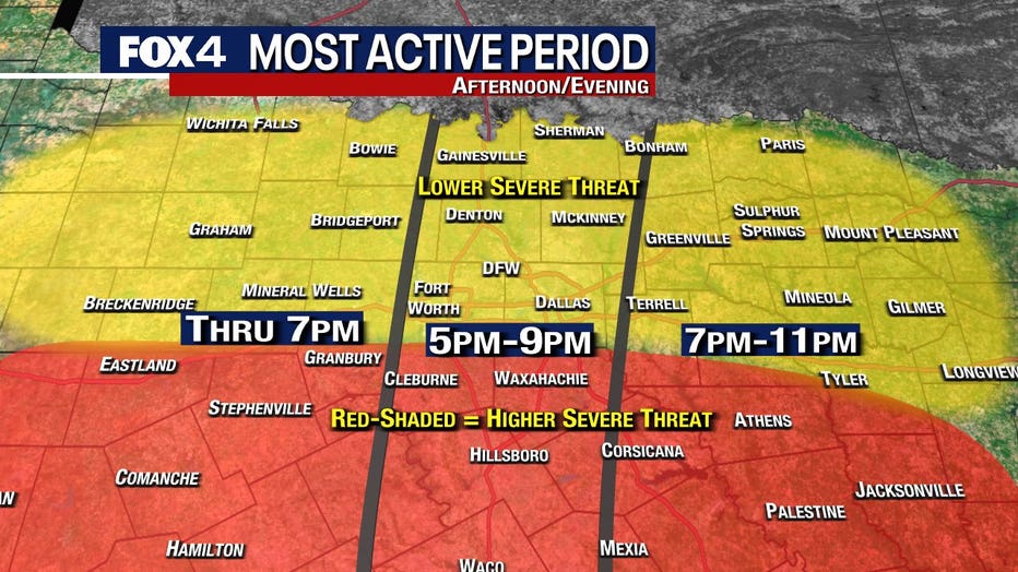
A Tornado Watch was issued Wednesday afternoon for several North Texas counties until 10 p.m.
Large hail pummels Eastland County home
Video taken by Debbie Copeland in Eastland County shows massive hail pummeling her home. Wildfires destroyed her home last year and just finished rebuilding. Now, their new roof has some damage from monster hail stones.
Video taken by Debbie Copeland in Eastland County shows massive hail pummeling her home. Wildfires destroyed her home last year and just finished rebuilding. Now, their new roof has some damage from monster hail stones.
READ MORE: What's the difference between Tornado Watch and Tornado Warning?
Severe weather Tuesday night brought marble to golf ball-sized hail to the Lake Tawakoni area, about 50 miles east of Dallas.

That storm was one of several that prompted Severe Thunderstorm Warnings from the National Weather Service.
Much of North Texas was under an ‘enhanced’ risk of severe weather for Wednesday evening. That is a 3 on the NWS Storm Prediction Center 1-5 scale. On Monday, the risk was ‘slight’, or a 2 on the 1-5 scale.
Storms popped up in the DFW area and dropped pea to penny-sized hail. The storms moved more quickly than expected meaning the more unstable air stayed south of the Metroplex.
Dublin reported seeing baseball-sized hail.
Dallas ISD canceled all after-school activities, including athletic events and programs, due to the chances of inclement weather.
Hail falls in Stephenville
FOX 4 viewer Nick Pernokas shared video of hail falling in Stephenville on April 26, 2023.
The storms also led to a ground stop at DFW and Love Field Airport.
98 flights have been canceled and more than 220 others have been delayed at DFW Airport Wednesday, according to flight-tracking site Flight Aware. Love Field has seen 24 cancelations and more than 70 delays.
Live Updates
Live Radar

7-Day Forecast

There is a lot of rain in the forecast this week.
Thursday there could be some leftover showers before a fast-moving storm moves into the area on Friday evening.
On the positive side, the weekend looks great!
After some early morning showers on Saturday, temperatures will be a bit cool with a high of 68.
High temps will top out in the high 60s on Saturday, before a big warmup on Sunday.