

Tornado-warned storm damages homes in parts of North Texas
DALLAS - Some severe storms left behind damage in North Texas on Friday.
The National Weather Service confirmed at least one tornado on the ground in Van Zandt County.
There are reports of damage to homes and trees in the area.
Van Zandt County Storm Damage
Storms leave trail of damage in North Texas
Tornado-warned storms left a trail of damage in Van Zandt County on Friday. FOX 4's Peyton Yager talked to families about what happened and where they will be looking to stay.
What we know:
911 calls began to come in around 3 p.m. in Grand Saline on Friday.
At least eight homes were damaged in the city, but that number could rise. No injuries have been reported.
Treeds, power lines and homes were severely damaged.
In the rain, crews were already at work clearing downed trees.
What we don't know:
Grand Saline crews are still surveying damage.
What they're saying:
The front of a home off of FM 1255 was damaged.
The homeowner, Kameron Martin, said the winds became concerning and the house started shaking as the storms came through.
Martin jumped in the bathtub as the storms rolled through.
"I heard the pop of the roof come off, and then I heard another pop. At the time, I didn't know what it was. It was my bedroom wall coming off the house. I just stayed in the bathroom for another 5 minutes, and then I came out and looked over things," Martin said.
After the storm passed, his second-story master bedroom is now completely exposed, trees were uprooted and the chain fence was destroyed.
Justina Goerdel's 2,000-pound porch was lifted up by the storm and wedged into the roof of her mobile home.
Now, Goerdel, her husband and their two children will stay in a nearby hotel for the weekend.
"It has been a lot emotionally. We came home it was raining and water and was all over the living room. My daughter's room it came in through her room too," she said. "I knew it was supposed to rain, but I didn't know it would be this bad."
Live Radar

Dallas Weather Forecast
Dallas weather: April 4 evening forecast
FOX 4 meteorologist Dan Henry takes a look at the storms that impacted North Texas on Friday and what you can expect for a rainy weekend ahead.
Saturday forecast: Heavy rain, wind and hail possible
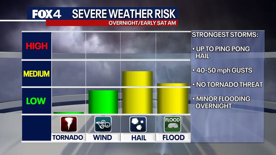
More storms will push through overnight. This will bring widespread rain and some storms will contain some hail. While most will be pocket change variety, we could see some up to ping pong size. We are not expecting a tornado threat and only localized strong, gusty winds.
An upper-level storm system is expected to arrive Saturday morning, bringing heavy rain, wind gusts up to 50–60 mph, and another round of hail potential. Temperatures will start off chilly near 50 degrees and stay in the 50s through the day.
Rain chances will taper off Saturday night, but clouds and gusty north winds will stick around. Evening temperatures will drop into the 40s, with light rain possible north and west of Dallas.
Sunday forecast: Feels like February
Sunday morning will feel brisk, with temperatures in the 40s and wind chills in the 30s.
There may be a brief afternoon break in the cold, but highs will stay in the 50s—about 20 degrees below normal for April.
7-Day forecast

Rain is expected to clear out next week, and winds will gradually diminish.
Monday morning will be the coldest start, with lows in the upper 30s. Highs will rebound into the mid-60s.
By Tuesday, temperatures will return to near-normal levels, reaching the 70s and 80s by midweek.
The extended forecast looks dry for now.
The Source: Information in this article comes from the National Weather Service and meteorologist Evan Andrews.