

Dallas weather: Sunday was the hottest day of the year, Monday will probably be hotter
Dallas weather: August 18 overnight forecast
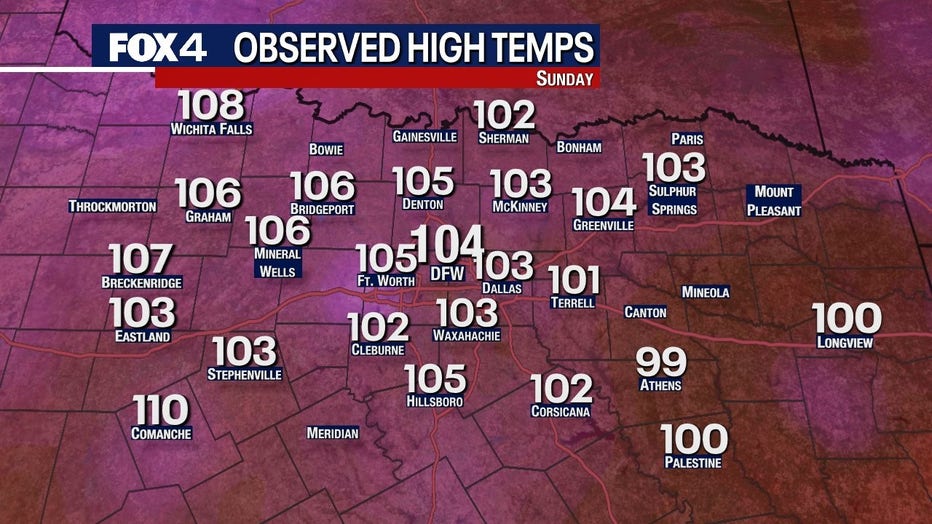
Sunday was the hottest day of the year in DFW. Monday is going to be even hotter. FOX 4 meteorologist Ali Turiano takes a look at the forecast for the next week.
Sunday is officially the hottest day of the year so far and Monday could be even hotter. Luckily, there is a dip in sight!
Temperatures climbed to 104 on Sunday afternoon, beating out the previous high of 103 earlier this month.
Excessive heat warnings are expected to stay in effect through at least Monday night.
The high pressure to our west will continue to dominate and dry the ground and the air. The drier air and increased sunshine will push temperatures to 105 or higher on Monday. West to southwest winds will compress the air and heat it more.

Some people in North Texas could see temperatures as high as 110 on Monday.
The one thing that will hold us back will be upper-level cloudiness and haze. If we don't have that, it could be hotter than our forecast.
7-Day Forecast

Our high pressure retreats back into New Mexico starting Tuesday and Wednesday, allowing an unseasonably strong jet stream in the eastern US to push a front westward through Texas. It's called a "back door" front because it moves from east to west, whereas most fronts normally move from west to east.
That front will bring 90s to areas east of Dallas on Tuesday as easterly winds develop. Unfortunately, areas from Fort Worth to the west won't get the front until late in the day. That may leave some still feeling 105-degree heat or higher.
With the front in the area, there is a very low chance for a storm on Tuesday. Even though it would be isolated, gusty winds would be possible.
The front should continue to push west on Wednesday, leaving us with easterly winds and highs in the 90s. It won't be cool, but certainly less hot.
Later this week, high pressure out west will head back into the western part of the state and then north into Oklahoma this weekend. It likely leaves us hot and dry but not in the core of the heat. Basically, expect highs in the 90s for most.