Beryl: Projected path, live tracking and impact to North Texas
When will Beryl hit Texas? Updated track, timing
Tropical Storm Beryl is expected to reach hurricane status again before making landfall on the Texas coast. FOX 4's Ali Turiano gives an update on some changes in the timing and track for the storm.
See Saturday's updated forecast here.
Beryl is now a Tropical Storm in the Gulf of Mexico, but it is expected to re-intensify into a hurricane before striking the Texas Coast.
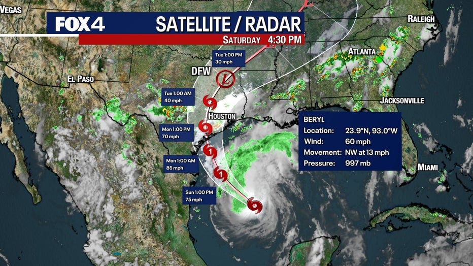
On Saturday afternoon, Beryl is continuing to churn in the warm waters of the Gulf with winds at 60 miles per hour.
That warm water will serve as fuel and the storm will likely return to hurricane strength Saturday night into Sunday morning.
When will Beryl make landfall?
The newest computer models show the storm making landfall east of Corpus Christi, near Port Lavaca, sometime on Monday morning.
We’re expecting the storm to reach hurricane status again by tomorrow afternoon and to make landfall as a Category 1 hurricane on Monday.
The latest updates have the storm arriving earlier than previously expected and on a more northern track.
The location of landfall is not likely to change, but the timing could vary between now and Monday.
It will make landfall between 5 a.m. and noon on Monday. Right now we believe landfall will be around 7 a.m., but that could change.

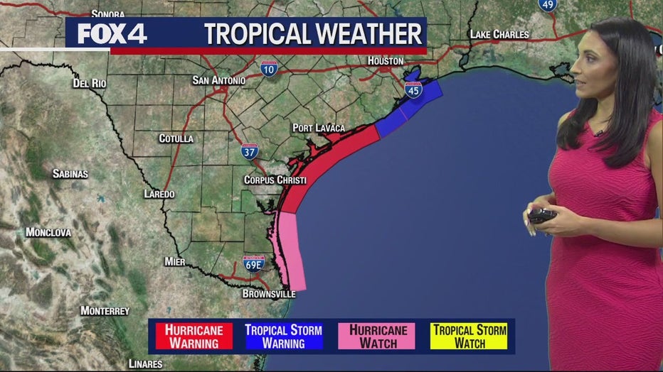
Hurricane warnings and watches have been put into effect for many areas along the Texas coastline.
Storm surge watches are in place from the Rio Grande Valley to the Galveston area.
Featured
State leaders warn Texans to prepare for Hurricane Beryl landfall: 'We're preparing for the worst'
"You want to be in a position of wherever you're going to be by Monday," said Lt. Gov. Dan Patrick.
Parts of Texas along the coast could see storm surges between 2 and 5 feet.
READ MORE: NOAA issues its most aggressive hurricane season forecast on record
Then there's the rain. Areas east of Corpus Christi could see about a foot of it.
Lt. Governor Dan Patrick added 81 counties to the state’s Hurricane Beryl Disaster Declaration, including Dallas, Hunt, Kaufman and Van Zandt counties.
TS Beryl: 81 TX counties added to disaster declaration
Texas is bracing for impact from now-Tropical Storm Beryl. The storm is expected to reach hurricane status by the time it makes landfall on Monday.
There will also be winds between 50 and 70 miles per hour.
The storm is expected to quickly weaken as it makes landfall.
Will Beryl hit North Texas?

It's important for North Texans to pay close attention to the forecast because the track of the storm will determine how much, if any, rain we expect to get.
The central track of the storm is taking Beryl to the north and east once making landfall.
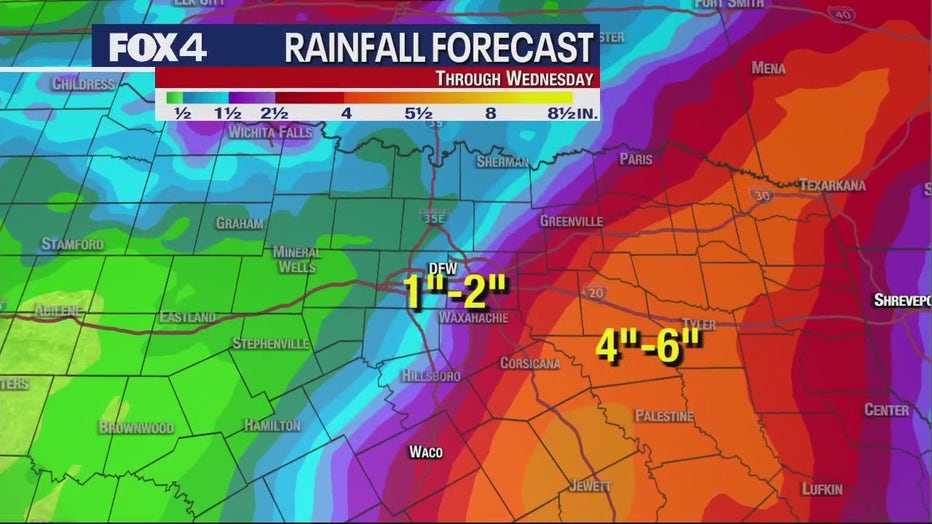
Right now, most of the rain is to the east and southeast of the DFW Metroplex, but it does look like North Texas could catch a bit of rain from the remnants of Beryl.
We have a 40 to 50 percent chance of rain for Monday and Tuesday in North Texas.
It will be feast or famine though. Some people could see flooding, other areas may not see a drop.

Chances will be higher the more east and southeast you go.
That is a lot of water in a short period of time, so it could even have some flood concerns for East Texas.
From Dallas, Fort Worth and westward, we will be able to handle it just fine.


