

Dallas weather: Winter Storm Watch extended, Extreme Cold Watch issued ahead of dangerous ice and snow
Wednesday weather briefing as Winter Storm Watch extended
Fox 4 chief meteorologist Dan Henry has a Wednesday weather briefing as the Winter Storm Watch was extended for North Texas ahead of this weekend's freezing temperatures.
DALLAS - North Texas is bracing for a significant winter storm this weekend as an arctic cold front brings the threat of dangerous ice, sleet and snow to the region.
Governor Greg Abbott announced Tuesday that he has directed the Texas Division of Emergency Management to activate state emergency response resources ahead of the storm. State agencies, including the Texas National Guard and the Department of Public Safety, are now mobilizing to assist with potential infrastructure impacts and stranded motorists as life-threatening temperatures move in.
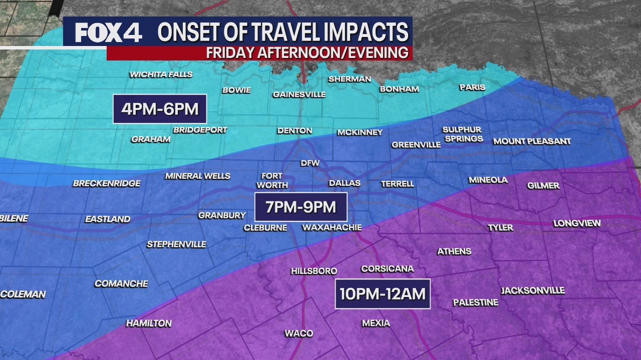
Dallas Winter Storm Watch: Timing and expected impacts

The National Weather Service has issued a Winter Storm Watch for North and Central Texas starting Friday afternoon and continuing through Sunday morning. An Extreme Cold Watch will also be in effect from Saturday evening through Monday morning.
FOX 4 forecasters warn that North Texas may not climb back above freezing until Tuesday afternoon, meaning the region could face nearly 100 hours of sub-freezing temperatures.

While the forecast remains susceptible to change, current data suggests a transition from cold rain to a wintry mix beginning Friday.
- North of DFW (Sherman, Paris, Graham): Sleet is expected to begin Friday night, transitioning to mostly snow by Saturday. Arrival is likely after 2 p.m. Friday.
- DFW Metroplex: Sleet is forecast to begin late Friday and continue into Saturday morning, ending as snow Saturday night. The most likely arrival time for the wintry mix in Dallas is 6 p.m. Friday.
- South of DFW (Waco, Palestine, Killeen): Freezing rain is expected Friday night, transitioning to sleet by early Saturday. The mix will likely arrive after 10 p.m. Friday.
Featured

ERCOT says Texas power grid ready for possible winter storm this week
The possibility of a winter storm impacting Texas this week has some residents nervous about a repeat of a 2021 winter storm that turned deadly when millions across the state lost power for days at a time.
Winter storm home preparation and pipe protection

Friday travel impacts update! New model data confirms will are likely to stay above freezing for a couple more hours Friday afternoon. We typically do not see ice accumulating until temperatures drop below 30 degrees. This estimate shows when we are
With a 50% chance that temperatures will drop below 10 degrees Saturday and Sunday nights, your plumbing is at high risk. Follow these steps now:
- Insulate Pipes: Wrap exposed pipes in attics, crawl spaces, and along outside walls.
- Disconnect Hoses: Remove garden hoses and sprinklers. If you have an outdoor shutoff valve, turn it off and drain the line.
- Drip Your Faucets: A slow drip from faucets near exterior walls can prevent pressure buildup and pipe bursts.
- Open Cabinets: Keep kitchen and bathroom cabinet doors open to allow warm air to reach uninsulated pipes.
- Maintain Heat: Keep your thermostat at a consistent temperature day and night; never set it lower than 55 degrees.
Featured

Dallas Weather: Cover your pipes before the ice and snow arrive
With temperatures dropping below freezing this weekend, you will likely need to take steps to prevent your pipes from freezing.
Winter weather checklist
The National Weather Service recommends completing all preparations before the front arrives Friday.
- Stock at least three days of non-perishable food, water, and medications.
- Bring pets indoors and ensure they have a warm space and extra water.
- Gather flashlights, batteries, and blankets in case of power outages.
- Fill your vehicle’s gas tank and check your emergency car kit.
- Test smoke alarms and carbon monoxide detectors.
What is a Winter Storm Watch?
A Winter Storm Watch is an alert issued by the National Weather Service (NWS) to give you a "heads up" that a major winter event is possible. It is generally issued 24 to 72 hours before the storm is expected to begin.
Think of it like the "ingredients" for a storm: the NWS sees the cold air, the moisture and the wind all moving into place, but the exact timing and location aren't 100% certain yet.
This means there is at least a 50% chance that significant winter weather (like heavy snow, sleet, or ice) will hit our area.
What's the difference between a Watch and a Warning? A Warning means the storm is "imminent" or already happening, meaning it's time to take action and stay off the roads. A Watch means it's time to get ready.
7-Day Forecast

Wednesday will see scattered showers and mild highs near 60, followed by a seasonal Thursday with highs in the upper 50s.

Dallas weather: Jan. 21 morning forecast
Major winter impacts are expected this weekend in North Texas. Meteorologist Ali Turiano has your forecast and everything you need to know about the upcoming storm.
The arctic front arrives Friday, transitioning rain to freezing rain from north to south. Sleet and snow will continue through Saturday with temperatures stuck in the 20s all day. While the precipitation is expected to end Sunday morning, dangerous cold will persist with lows in the teens and highs in the 20s.
Frigid conditions remain Monday before the region finally climbs above freezing Tuesday afternoon.
Live Radar: Dallas-Fort Worth

The Source: Information in this article comes from the National Weather Service, FOX 4 meteorologists and previous coverage.