This browser does not support the Video element.
Dallas weather: March 30 overnight forecast
Ali Turiano covers the latest in weather as severe thunderstorms comes and goes as the week continues with flood threats increasing toward the end of the week.
DALLAS - A Severe Thunderstorm Watch has ended for much of the region.
An update from the National Weather Service ended the watch in much of the Metroplex. Areas to the east will remain under the watch until 10 p.m.
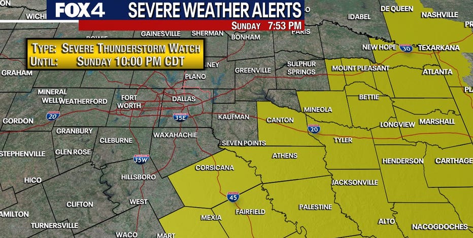
Some areas have already seen storms, high winds and hail.
Tarrant County was under a Severe Thunderstorm Watch until 4:45 p.m.
This browser does not support the Video element.
Fort Worth hail
Hail fell in parts of Tarrant County on Sunday night. Viewer Kenneth Janak sent video of some hail from Fort Worth's Ridgmar neighborhood.
Live Radar
LIVE: Downtown Fort Worth – Burnett Plaza
Sunday Forecast
This browser does not support the Video element.
Dallas weather: Your March 30 morning forecast
Across North Texas, significant storms moved through late Saturday night into early Sunday morning. FOX 4 Meteorologist Kylie Capps has the forecast for the rest of the day and into this workweek.
Morning:
Round three is associated with a cold front. That front looks to drop into the metroplex between 3 and 4 p.m., and then we'll likely see showers and storms develop, mainly east of I-35 and south of I-30 later on today.
For Sunday, it will be in the upper 60s to start. Most of us are still warm and muggy, waiting for the arrival of that front. That front will be approaching from the north and west over the next several hours, but we'll slow down slightly, not getting into the metroplex until about 3 p.m. or 4 p.m., and that leaves us plenty of time to warm up. And we will really warm up, topping out in the upper 80s this afternoon ahead of that front.
Afternoon:
And because there's plenty of time for the atmosphere to heat back up, as well as plenty of moisture to work with, there will be another risk for strong to severe storms later on. That's where the storm prediction center has parts of North Texas under Level 2. That means slight risk, large hail and damaging winds are the main threats once again.
Timeline:
And that's going to be likely after 4 p.m., continuing through to about 10 p.m. as far as that timing is concerned. Similar to the storms that we saw last night, hail up to the size of golf balls will be possible, as well as 50 to 60 mph wind gusts.
With the front approaching the metroplex mid-afternoon, we will start to see the development of some showers and storms, especially ahead of the front for the far southeastern parts of North Texas through 10 p.m. The rest of the night looks quiet.
7-Day Forecast
Monday Forecast
Tomorrow morning we wake up to some extra clouds, but by the afternoon, we are back in the low 70s. Lots of sun, a little bit of a breeze. We're going to enjoy tomorrow while we have it, because by the middle of the week, a very active weather pattern returns to the forecast with multiple rounds of showers and storms. Several will have the potential to produce severe weather, and it looks like some pretty heavy rain will be setting up through part of next weekend, too.
The Source: Information in this article comes from the FOX 4 Weather team.