

Dallas weather: Winter Storm Warning issued for North Texas

Thursday weather briefing as winter storm sets in on North Texas
The winter storm will arrive in North Texas tomorrow with temperatures expected to drop throughout the day. FOX 4 chief meteorologist Dan Henry has a weather briefing ahead of its arrival.
DALLAS - Are you geared up, North Texas? A Winter Storm Warning and an Extreme Cold Warning are in effect as multiple inches of sleet and snow are expected. Temperatures later this weekend will struggle to climb above single digits in most areas, with wind chills dropping below zero.
Here is everything you need to know to prepare for the incoming extreme weather.
Texas Weather: Winter Storm January 2026

Dallas weather: Jan. 22 evening forecast
A Winter Storm Warning is in effect for the metroplex through the weekend. Find out when it starts in Dan Henry's Jan. 22 evening Dallas forecast.
What we know:
The National Weather Service has now issued a Winter Storm Warning for North and Central Texas starting at 6 p.m. on Friday and continuing through noon on Sunday. An Extreme Cold Warning will also be in effect from Saturday evening through Monday morning.
FOX 4 forecasters warn that North Texas may not climb back above freezing until Monday afternoon, meaning travel could be dangerous until Monday evening.
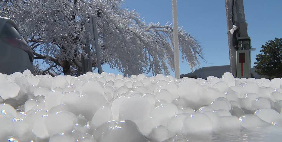
A full changeover to sleet and snow is expected across parts of North Texas late Saturday before the wintry weather ends Sunday, according to the NWS. Power outages are possible due to ice accumulating on trees and power lines.
Weather tomorrow: Snow and sleet timing

While the forecast remains susceptible to change (last updated Thursday afternoon), current data suggests a transition from cold rain to a wintry mix beginning Friday.
North of DFW (Sherman, Paris, Graham): Rain and some ice are expected on Friday night, transitioning to sleet and snow on Saturday. Significant accumulations are expected as the day wears on.
DFW Metroplex: Rain is forecast to begin on Friday night, transitioning into freezing rain after midnight. There will be periods of freezing rain and sleet on Saturday morning and afternoon with heavy sleet at times on Saturday night. It ends as snow on Sunday morning. Significant accumulations of ice (freezing rain/sleet) are expected with minor snow accumulations too.
South of DFW (Waco, Palestine, Killeen): Rain is expected Friday night into early Saturday. A wintry mix will likely arrive during the day on Saturday.
Featured

Ted Cruz spotted on a plane to Laguna Beach ahead of Texas winter storm
A photo of Senator Ted Cruz on a plane to Laguna Beach as Texas braces for a winter storm is drawing a lot of attention.
How many inches of snow this weekend in Dallas?

Winter Storm Texas: ERCOT and ONCOR preparing for ice
North Texas is preparing equipment and getting crews in place to respond to this weekend's winter storm. FOX 4's Dan Godwin has full details on how Dallas and surrounding cities are planning to keep ice from forming when the storm hits.
Accumulating ice from freezing rain will occur before the transition to sleet and snow, the NWS says. Residents should prepare for icy roads and weighed-down power lines.
- Ice: Much of the area could see 0.25 to 0.5 inches of ice.
- Sleet/Snow: Totals of 2 to 5 inches are forecast for areas north of Interstate 20.
- Metroplex: Combined snow and sleet amounts in Dallas-Fort Worth are projected to be between 2 and 4 inches.
By Saturday evening, travel across most of the region will likely be impacted by accumulations.
Extreme Cold Warning

In addition to the wintry mix, dangerously cold temperatures will sweep through the region. Wind chills in Dallas-Fort Worth will make the air feel like minus 3 degrees on Sunday.
While low temperatures will reach roughly 8 degrees, some areas northwest of the Metroplex could see wind chills as low as minus 6. Throughout North Texas, lows will remain in the teens or single digits.
How to prepare for winter storm
With a 50% chance that temperatures will drop below 10 degrees Saturday and Sunday nights, plumbing is at high risk. Follow these steps now:
- Insulate Pipes: Wrap exposed pipes in attics, crawl spaces, and along outside walls.
- Disconnect Hoses: Remove garden hoses and sprinklers. If you have an outdoor shutoff valve, turn it off and drain the line.
- Drip Faucets: A slow drip from faucets near exterior walls can prevent pressure buildup and pipe bursts.
- Open Cabinets: Keep kitchen and bathroom cabinet doors open to allow warm air to reach pipes.
- Maintain Heat: Keep your thermostat at a consistent temperature; never set it lower than 55 degrees.
Featured

City of Dallas prepares for extremely dangerous winter storm
While most of North Texas is still in the calm before the storm, Dallas leaders are busy preparing for what’s expected to be an extremely dangerous winter storm.
Winter Weather Checklist
The NWS recommends completing all preparations before the front arrives Friday:
- Stock at least three days of nonperishable food, water, and medications.
- Bring pets indoors.
- Gather flashlights, batteries, and blankets.
- Fill vehicle gas tanks and check emergency car kits.
Featured
Dallas weather: Prepping your pipes for freezing temperatures
Follow these tips to make sure your pipes don't freeze during the upcoming North Texas winter storm.
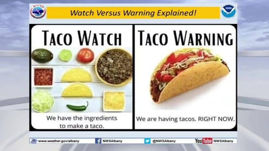
What is a Winter Weather Watch vs. Warning?
A Winter Storm Watch is issued 24 to 72 hours before an event when significant wintry weather is possible but the exact timing is still uncertain.
A Warning means the storm is imminent or occurring. When a Warning is issued, it is time to take immediate action and stay off the roads.
State of Emergency Texas

Gov. Greg Abbott directed the Texas Division of Emergency Management to activate state emergency response resources Tuesday. State agencies, including the Texas National Guard and the Department of Public Safety, are mobilizing to assist with infrastructure impacts and stranded motorists.
School Closings
It is unclear at this time whether North Texas schools will be closed early next week, as most districts wait for the front to arrive before making final calls. However, significant changes have already been made to school schedules and athletic events across the DFW Metroplex.
FULL LIST OF CANCELED ACTIVITIES IN NORTH TEXAS
7-Day Forecast

Thursday will be the last mild day of the week, featuring highs in the low 60s and partly to mostly cloudy skies. Most of Friday will feature liquid rain, but a changeover to frozen precipitation is expected between 7 p.m. and 9 p.m., beginning along the Red River before moving into the Metroplex and eventually further south.
Wintry precipitation will continue through Saturday before shifting east on Sunday. Once temperatures hit the freezing mark, the region will stay at that level or colder for roughly 72 hours. Temperatures are expected to plummet into the teens, with wind chill values as low as minus 5 degrees. Travel impacts are likely and power outages are possible throughout the weekend.
LIVE Radar: Dallas-Fort Worth

The Source: Information in this article comes from the National Weather Service, FOX 4 meteorologists and previous reporting.