

Dallas Weather: More rain and hail chances in the forecast
Dallas weather: April 3 evening forecast
FOX 4's Ali Turiano and Dan Henry walk you through the storms from the morning and what we can expect heading through this weekend with heavy rain expected.
DALLAS - The Severe Thunderstorm Watch that was issued by the National Weather Service for most of North Texas on Thursday morning has now expired.
According to the FOX 4 Weather team, the storms that are lingering on the radar are no longer severe. Their intensity has diminished.


Warning, Watch, Advisory: What's the difference?
A large part of Texas is expected to see temperatures dip below freezing. Throughout the rest of winter, you will hear meteorologists use terms like warning, watch and advisory, but what do they mean?
Large hail falls west of DFW
Large hail falls in parts of North Texas
Some parts of DFW saw quite a bit of hail this morning. FOX 4's Payton May is in Tarrant County with weather updates.
FOX 4 storm chaser Michael Beard spotted hail larger than the size of a quarter in Jacksboro on Thursday morning.
He also shared photos of a field of pea-sized hail on the ground in Bowie.
According to the FOX 4 Weather Team, the forecast called for up to egg-sized hail and 60 mph winds. That all stayed west of the Dallas-Fort Worth metroplex.
DFW, Love Field Flight Delays
As the severe weather hit North Texas, many flights to both DFW Airport and Love Field Airport were canceled or delayed.


DFW flight cancellations and delays: More than 150 affected Thursday
DFW Airport representatives told FOX 4 that it leads the nation in flight cancelations Thursday.
Power Outages
Power outages peaked at around 3,500 customers in North Texas at 6 a.m.
The majority of the outages were in Eastland and Young counties where the storms were the strongest.
Live Radar

Friday Forecast
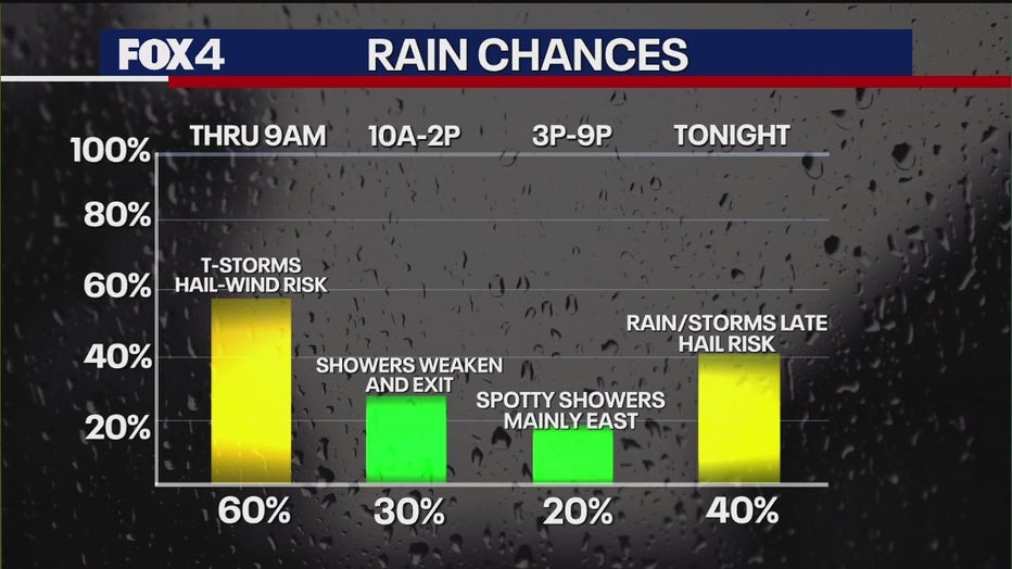
Storms will weaken and exit during the day on Thursday. Then, new showers and storms will develop after midnight, but those will have a lower risk of hail.
Then on Friday and Saturday, a system that is currently producing snow in Colorado will move toward Texas and push a big batch of rain into North Texas. Coverage will be nearly 100%.
East and southeast of DFW will be on the warmer side and could easily see severe weather, including a tornado risk. The highest coverage will be overnight Friday, which will exit quickly Saturday morning.
Weekend Forecast

By Saturday afternoon, we will be on the windy, cooler side of the storm. Temps will only be in the 60s with brisk northern winds and clouds. There's a low chance for patchy rain west/NW of the DFW area as well. PM-eve hours. Not a real spring day for sure.
Sunday is dry but chilly as north breezes continue. Wind chills in the 30s to start the day! Clouds will start to break up, but we'll struggle to get out of the 50s, with the "average" here about 75.
The Source: Information in this article comes from the FOX 4 Weather team.