

Dallas weather: Tuesday storms bring hail, showers across North Texas
Dallas Weather: March 25 overnight forecast
Dan Henry has the latest in Dallas weather in tonight's overnight forecast.
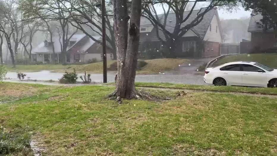
DALLAS - Tuesday afternoon's storms brought some isolated showers and even hail to some parts of North Texas.
The chance of storms will go into the night.
Weather Updates: Blog
10:00 p.m.
A pair of severe storms is impacting Collin and Rockwall counties. Both storms are still capable of producing ping pong hail. Hail may accumulate enough to cover the ground in some spots.
9:30 p.m.
8:37 p.m.
Several storms have popped up going into 9 p.m. Dan Henry will have an update on FOX 4 News at 9.
8:12 p.m.
A new warning has been issued for northern Dallas and southern Collin counties with hail up to the size of quarters and gusty winds up to 60 mph possible.
7:43 p.m.
The thunderstorms prompted a ground stop at DFW Airport until the storms pass.
7:41 p.m.
More Severe Thunderstorm Warnings have been issued for Dallas and Tarrant counties until 8 p.m.
7:15 p.m.
7:09 p.m.
Severe Thunderstorm Warnings have been issued for Dallas, Ellis, Fannin and Hunt County until 7:30 p.m.
7:00 p.m.
Isolated storms wind down early this evening, but expect more development late tonight into Wednesday (esp. NE). Heavy rainfall is possible. The pattern stays unsettled with more rain chances Thursday and Friday. We will be much drier by the weekend and early next week.
6:35 p.m.
All Severe Thunderstorm Warnings issued for parts of North Texas have been allowed to expire.
The warnings expired at 6:30 p.m. in Dallas County and Johnson County on Tuesday.
Wednesday’s Forecast: Showers
What's next:
Showers will develop Tuesday night and continue into Wednesday morning, mainly near the Red River. Clouds and easterly winds will help keep temperatures cooler than Tuesday, with most areas staying in the 70s to near 80 degrees.
Thursday and Friday: Wet Weather Ahead
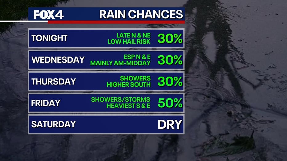
The bulk of the rain will arrive Thursday into Thursday night. Clouds and showers will hold temperatures in the 70s both days. While storms are expected, they are not forecast to be severe.
Weekend Look Ahead
Storms are expected to clear out by Saturday morning, with south winds returning and pushing the dry line back into North Texas. This could lead to warm and windy conditions, with highs in the 80s and 90s to the west.
Overnight Saturday into Sunday morning, a potential cold front disturbance could bring low storm chances. However, there is a risk for severe weather, including strong winds and hail. Temperatures will remain warm.
7-Day Forecast

The Source: Information in this article comes from the National Weather Service and meteorologist Evan Andrews.