

Dallas weather: Severe weather risk, including egg-sized hail early Thursday
Dallas weather: Large hail, severe storm risk Thursday
FOX 4 meteorologist Dan Henry takes a look at the potential for severe storms and large hail in North Texas on Thursday morning.
DALLAS - Scattered storms could bring large hail early Thursday morning.
About 50 percent of the area is expected to see storms and some of the strongest could bring hail greater than two inches.
If you can, park your car under a covering.
Latest Information
A Severe Thunderstorm Warning has been issued for Northeastern Young County and Northern Jack County until 4:45 a.m. At 3:50 a.m. a severe thunderstorm was located 9 miles northwest of Bryson, or 13 miles northeast of Graham, moving northeast at 55 mph.
Ping-pong ball-sized hail and 60 mph wind gusts were detected.
Jermyn, Antelope, Loving, Cundiff and Postoak could be impacted by this storm.
Thursday forecast: Hail, strong storms possible
There is an enhanced risk of severe weather overnight.
We could see egg-sized hail, 60 mile per hour winds and a very low-end chance of tornadoes in areas that do see storms.
To put things in perspective, most of the area will see hail much smaller than egg-sized, or no hail at all.
Timeline:
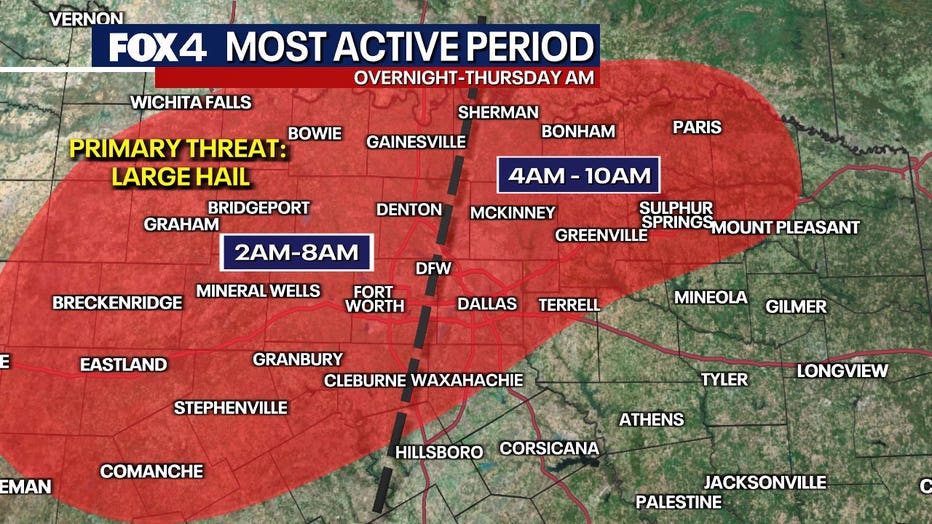
The main timeframe for storms depends on where you live.
The highest storm chances for the western half of the DFW Metroplex will be about 2 a.m. to 8 a.m.
To the east, the storm chances are highest from 4 a.m. to 10 a.m.
Areas to the south and southeast will likely be out of the track of most of the storms.
Live Radar

Live Camera: DFW International Airport
Live Camera: Downtown Dallas - Bank of America Plaza North
Live Camera: Downtown Dallas - Bank of America Plaza South
Live Camera: North Dallas – Pinnacle Tower
Live Camera: Downtown Fort Worth – Burnett Plaza
7-Day Forecast

The main upper-level storm responsible for the active weather will remain in the desert southwest Friday before moving out Friday night into Saturday. That will cause rounds of rain and storms to develop. It will be on the cooler side and there will be heavy rain.
East and southeast of DFW will be on the warmer side and could easily see severe weather, including a tornado risk. The highest coverage will be overnight Friday, which will exit quickly Saturday morning.
By Saturday afternoon, we will be on the windy, cooler side of the storm. Temps will only be in the 60s with brisk northern winds and clouds. There's a low chance for patchy rain west/NW of the DFW area as well. PM-eve hours. Not a real spring day for sure.
Sunday is dry but chilly as north breezes continue. Wind chills in the 30s to start the day! Clouds will start to break up, but we'll struggle to get out of the 50s, with the "average" here about 75.
The Source: Information in this article comes from the FOX 4 Weather team.