

Dallas flooding: Another round of storms expected overnight

Dallas weather: May 31 forecast - 1 a.m. Update
FOX 4's Dan Henry is watching the storms moving through North Texas early Friday morning.
More storms are moving through North Texas on Thursday night.
A flash flood warning is in effect for parts of the area through 2:30 a.m.
It's been a rainy day.

Water rescues and power restoration delays
The latest round of storms caused some serious flooding problems in parts of North Texas. Most of the issues affecting roads and drivers and power restoration efforts.
The first system developed out to the northwest on Thursday morning and brought heavy rain to the area in the afternoon.
Flash flood warnings and severe thunderstorm warnings were issued for Dallas-Fort Worth earlier in the day but have since expired.
READ MORE: Oncor power outages: Electricity restoration to be 'substantially complete' by Friday
It was not the wind but the water that menaced parts of North Texas Thursday.
SKY 4 was overhead as Dallas Fire-Rescue worked to reach a city of Dallas employee who was stranded in his work truck by rising waters at Moss Soccer Park in North Dallas.
"Once we arrived, we realized he was out there really close to the current, so it was kind of a hectic situation and scary for him," said DFR Battalion Chief Michael Meador.
Although the water was not high, it was fast-moving and also on the rise.
"Still rising. Potential for more storms to come through, which means it's just going to rise more," Meador said.
The city worker, Marcus Williams, told FOX 4 he had gone to make a repair at the park when the water started rising. When he called for help, officials told him to stay put for fear the current would knock him over.
"Right now, the water's still rising as we speak. So my truck will probably be underwater in the next hour," he said.
The high water also led to road closures in flood-prone areas like Park Central and 635.

Flash flooding along White Rock Creek
This was the scene Tuesday afternoon along White Rock Creek and I-635.
In other spots, the water caught folks by surprise.
Carol Hoff said her car stalled near her North Dallas home when a clogged storm drain backed up.

Traffic drives through flash flooding in Dallas
Drivers dangerously drive through high waters along Market Center and I-35E
"The water, when I went through it, I didn't think it was that high," she recalled. "And then I got through it, and it was deeper than I thought. And obviously my car just died."
The stormy pattern is making things more difficult for city crews and Oncor as they work to clean up and make repairs. It says Thursday's storms caused fresh outages and impacted crews working to restore power from storms earlier this week.
Oncor still says most will have power back on Friday. But some in harder-hit areas like North Dallas, East Dallas and Mesquite might not get it back until Saturday.
Overnight Storm Chances
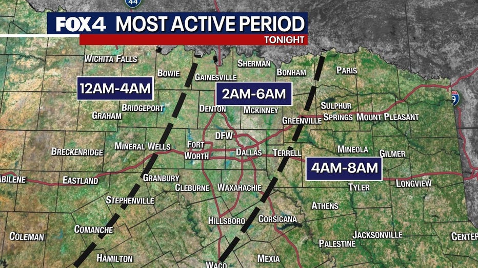
North Texas saw a break in storms Thursday evening, but another disturbance is coming. The stronger storm will likely be later into the night.
READ MORE: List: Cooling centers for North Texans without power
The first storms are expected to develop out west around 10 p.m. We would not expect to see rain in the Metroplex until midnight to 4 a.m.
The areas to the west have the best chance of strong storms.
The good news is because the storms hold together in the afternoon, it will eat away at the energy for the next round of storms, meaning they will likely be a bit weaker by the time they hit DFW.
READ MORE: Valley View warning siren malfunctioned during tornado, fire department confirms
We aren't expecting anything as intense as the storms we saw Tuesday morning.
We could also see half dollar-sized hail and 60 mph wind gusts. There is also more of a flooding threat because of how saturated our ground is.
Most of North Texas is under a "slight" risk of severe weather, according to the Storm Prediction Center. That's a 2 out of 5.
There is a higher risk out to the west.
DFW Live Radar

7-Day Forecast

Rain chances will stick around through the weekend.
On Friday a few scattered showers and storms could stick around until the middle of the day.
Another complex could move through the area Saturday night into Sunday morning.