

Strong El Nino winter: What kind of weather you can expect
The meaning of El Nino and La Nina
The status of whether the world is being impacted by an El Nino or a La Nina is determined by water temperatures in the central and eastern Pacific. (NOAA)
NOAA released its latest El Niño discussion, which showed a 95% chance of the phenomenon hanging on through winter and a 71% chance of it being strong.
"El Niño is anticipated to continue through the Northern Hemisphere winter (with greater than 95% chance through January - March 2024," wrote NOAA scientists.
NOAA reports that the current state of El Niño is strong, with sea surface temperatures 1.6 degrees Celsius above average.
HERE'S WHAT AN EL NINO CLIMATE PATTERN IS
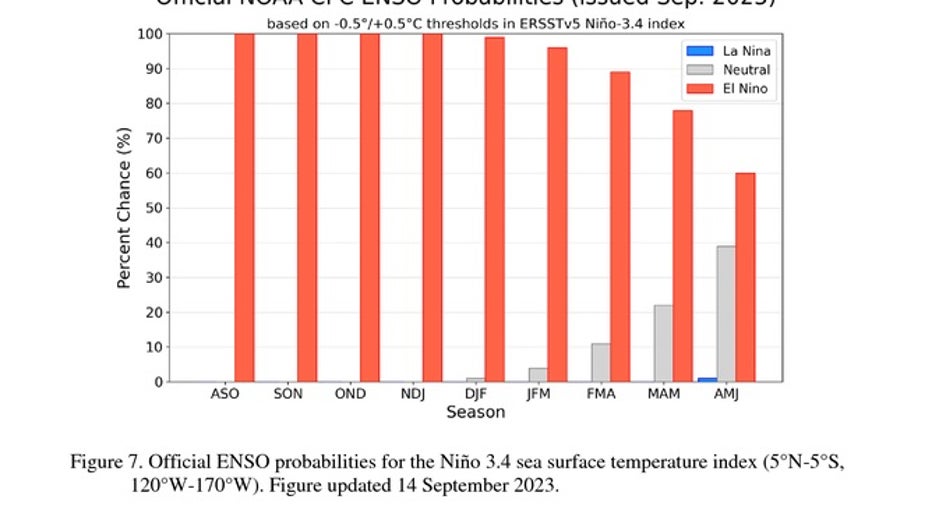
Official NOAA El Nino/Southern Oscillation probabilities by month. (NOAA)
What is El Nino?
Warming sea surface temperatures in the central-east equatorial Pacific led to the formation of this El Niño climate pattern. The warming can have significant impacts on global weather
Some have dubbed El Niño to be the world’s ultimate "master weather-maker" as its influences impact everything from animal migrations to the number of billion-dollar disasters reported around the globe.
Due to a rare triple-dip La Niña event that began in 2020, the world hasn’t seen the impacts of an El Niño since 2019, and the last strong occurrence was back in 2015-16.
What will El Nino mean for your weather?
West
During strong El Niño events, the West has endured a colder and rainier winter. A greater than usual number of storms, one after another, punch through south and central western states, according to the U.S. Geological Survey. During the 2015-2016 winter, large amounts of rain fell along the coast, and snow piled up in the mountains.
"In California, historically some of the heaviest precipitation, and all of the largest flood years have been non-El Niño years," states the USGS website.

U.S. winter precipitation outlook, chances of being wetter or drier than on average. (NOAA)
RIDICULOUS PHOTOS SHOW AFTERMATH OF 12 FEET OF SNOW IN CALIFORNIA'S SIERRA NEVADA
A larger number of more intense storms could trigger floods, landslides and coastal erosion. The storms could start as soon as October, according to the USGS.
Much of California is still cleaning up after a parade of atmospheric river-fueled storms brought record rain and snow during the past winter.
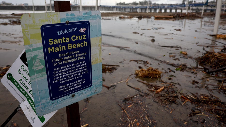
Flooded beach volleyball courts are viewed on Main Beach on January 11, 2023 in Santa Cruz, California. (Photo by Mario Tama/Getty Images)
The Pacific Northwest has traditionally been drier and warmer during El Niño years. What would normally have been snow would be rain.
"These conditions tend to favor a thinner winter snowpack and subsequently less meltwater in the spring," wrote the USGS. "An El Niño can potentially create conditions for more severe flooding in the wetter winter months and possibly drier spring and summer months in the Pacific NW."
FARMERS' ALMANAC DECLARES ‘THE BRRR IS BACK’ WITH PREDICTED ‘SNOWY’ WEATHER IN WINTER OUTLOOK

During an El Niño winter, the temperatures in the northern U.S. are usually warmer and drier than average, and the southern parts of the continental U.S. are usually cooler and wetter. (NOAA)
"In addition to the obvious effects El Niño can have on storms, floods and coastal hazards, it can also affect long-distance migratory birds, the snowpack in the mountains of the western U.S., fire seasons in Alaska and across the continental U.S., the health and distribution of oceanic and freshwater fish, and even very local environments such as the sediment and algae in the waters of San Francisco Bay," continued the USGS.
Southeast, Gulf Coast and Texas
The area from the mid-Atlantic states through Florida, then along the Gulf Coast, including much of Texas, is generally cooler and wetter. Northern storms generally track further south, producing more clouds, rain and severe weather, according to the NWS.
In strong El Niño years, data collected from 1950 to 2009 shows an average of 20 tornado events per year across the Tampa Bay, Melbourne and Miami areas of Florida, according to the NWS. That number is more than twice the average number.
The same areas found about 23 flood events per year during a strong El Nino year compared to under five in a neutral year.
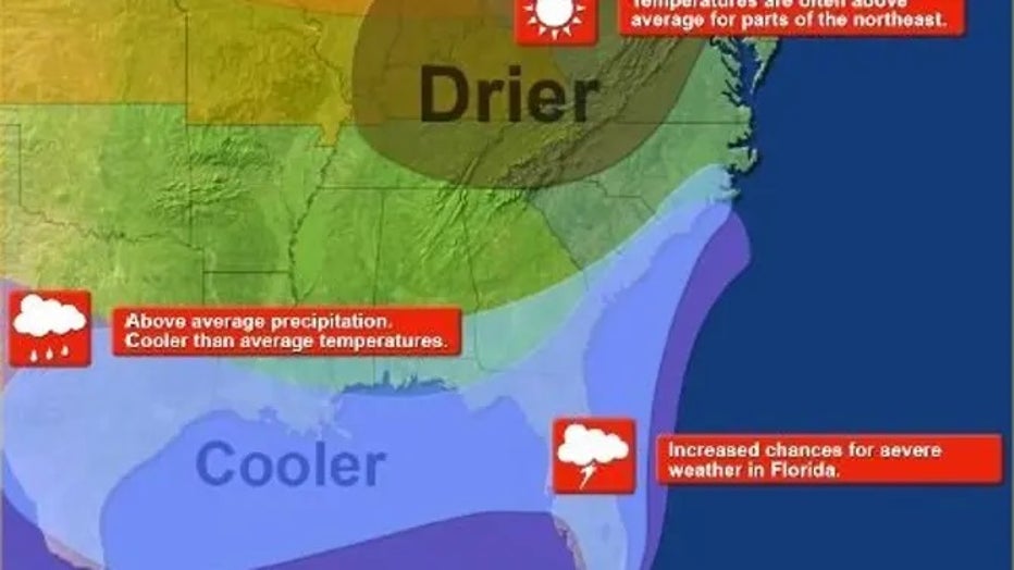
El Nino impacts to southern states. (NOAA)
"El Niño generally brings above-average precipitation to Florida during Fall-Winter-Spring, reduced risk of wildfires and higher risk of flooding, wrote the NWS. "Increased storminess across the southern U.S. increases the threat of severe weather in Florida during El Niño winters."
This could be a boon for Texas, Louisiana and Mississippi. The states are suffering through extreme and exceptional drought, according to the U.S. Drought Monitor. In Texas alone, almost 44% of the state is in extreme drought and almost 20% is under exceptional drought.

The Drought Monitor as of September 14. (US Drought Monitor / NOAA)
Southern Mississippi had the driest August on record. The first half of September has only netted a half-inch of rain in some areas.
Northern tier of the US
The northern third of the country could see fewer Arctic blasts. The jet stream generally flows more west to east instead of north to south. You can think of the jet stream as the separation between cold and hot. For example, we had a ridge over Texas for much of the summer, which was responsible for record heat.
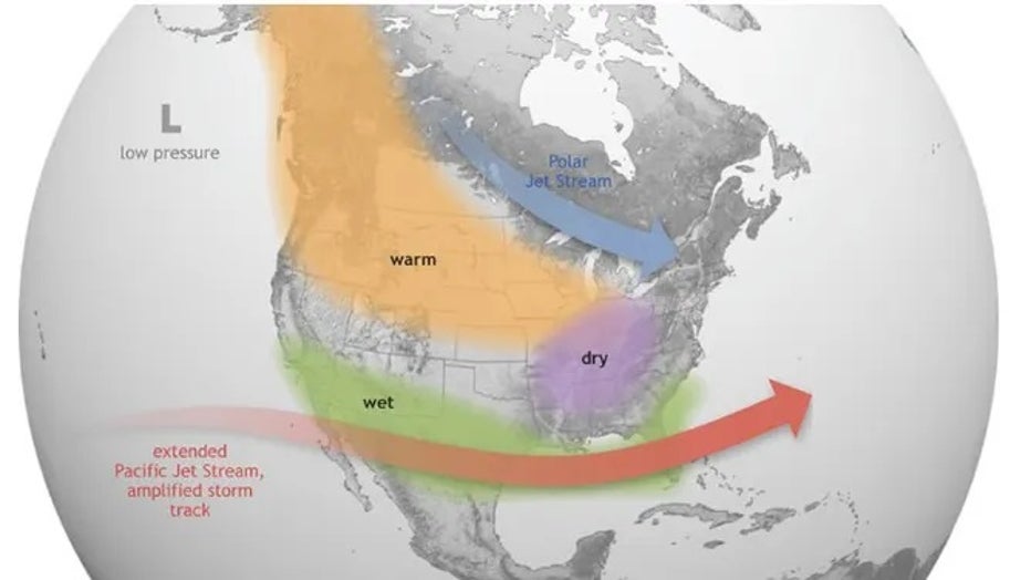
El Nino causes the Pacific jet stream to move south and spread further east. During winter, this leads to wetter conditions than usual in the southern states and warmer and drier conditions in the north. (NOAA)
The warmer, dryer pattern usually means less ice cover for the Great Lakes, followed by warmer water temperatures the following summer, according to the Cooperative Institute for Great Lakes Research.
The Ohio Valley and Great Lakes have seen less snowfall during strong El Niño years, except for areas with lake-effect snow.
Northeast and New England

Vehicles are seen abandoned in heavy snowfall in downtown Buffalo, New York, on December 26, 2022. (Photo by JOED VIERA/AFP via Getty Images)
The Northeast and New England tend to experience more average conditions.
"It is more difficult to define conditions in the northern sections of the Eastern Region because of other atmospheric and oceanic influences," states the American Geosciences Institute.
Hawaii
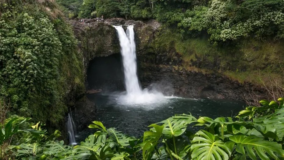
Visitors stand atop Rainbow Falls on December 14, 2016, near Hilo, Hawaii. Hawaii. (George Rose / Getty Images)
Hawaii tends to be wetter than normal through October. The islands are usually much drier than normal from November through July, according to AGI.
LINK: Get updates and more on this story at foxweather.com.