Hurricane Helene unleashes fury on Mexico submerging Cancun resorts in torrential rain: 'Beach gone'
Storm chaser Mike Boylan gears up for Helene
As we continue to track Hurricane Helene, we caught up with viral storm chaser Mike Boylan, who runs Mike's Weather Page, as he prepares to chase Hurricane Helene.
Hurricane Helene, intensifying from a tropical storm, struck Mexico's coastal state of Quintana Roo on Wednesday, bringing heavy rain and strong winds to Cancun and surrounding areas.
As the Category 1 hurricane formed Wednesday morning, it unleashed its fury in the Caribbean as its destructive eye is now set on the Florida coast with a life-threatening landfall expected on Thursday. The National Hurricane Center said that the storm would bring "life-threatening storm surge, damaging winds and flooding rains" as it heads toward the U.S. Gulf Coast.
Currently, Helene is lashing western Cuba and the Yucatan Peninsula. Along the storm's path is Cancun, home to some of the most beautiful beaches in Mexico.
"Rode out Beryl here in July, that was a rain storm compared to what’s happening outside my window right now," said Michelle Koleychik, posting video on X from outside her hotel room. "It’s a monsoon out there. Strong winds & heavy rain. Beach gone."
Koleychik was starting to panic as water began to pour into her room from everywhere.
"I’m out of towels. My bed is now an island," she added.
BREAKING: Helene now a hurricane
Helene reached hurricane strength Wednesday morning as it continues to undergo rapid intensification along its journey into the Gulf of Mexico, where it is aiming for a destructive landfall along the Florida Gulf Coast on Thursday. The National Hurricane Center provided an update.
Hunter Keeling was visiting the resort town and has been documenting the storm's progress after winds picked up Tuesday night as she observed how the resort had prepared for Helene.
TRACKING HURRICANE HELENE: LIVE FORECAST CONE, SPAGHETTI MODELS, ALERTS, WIND PROJECTIONS AND MORE
This video from Steven Mangini, who said he had traveled to Mexico from Manchester, England, shows conditions deteriorating at Hotel Riu Dunamar in Cancun on Wednesday morning.
Footage from Jodi Whoriskey, another U.S. hotel guest and travel agent staying in Playa Del Carmen, captured Helene's heavy rain and powerful winds.
"Hunkering down waiting for Helene to pass," she said in a post on X.
Lightning was seen in the night sky above Merida, in Mexico’s Yucatan Peninsula, early on Wednesday as the intensifying Helene passed along the country’s Gulf Coast.
Hurricane Helene expected to be a category 3+
Helene reached hurricane strength Wednesday morning as it continues to undergo rapid intensification along its journey into the Gulf of Mexico, where it is aiming for a destructive landfall along the Florida Gulf Coast on Thursday. LiveNOW from FOX host Christina Matino spoke to former St. Petersburg MAyor Rick Kriseman about the potential impacts to the area.
As Helene intensifies, its wind field is expanding dramatically, the FOX Forecast Center said. This exceptionally large storm could bring strong winds up to 400 miles from its center, making the traditional forecast cone less reliable.
UTILITY CREWS FROM ACROSS US HEADED TO FLORIDA TO AID IN POWER RESTORATION EFFORTS IN WAKE OF HELENE

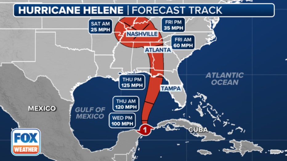
The forecast track for Hurricane Helene. (FOX Weather)
Nearly all of Florida, including areas outside the cone, should brace for strong to damaging wind gusts. Power outages are likely to be widespread. The most destructive winds are expected in the Big Bend region and along the Interstate 10 corridor, with gusts potentially exceeding 100 mph. This could lead to significant structural damage.
Rain will begin spreading across the state on Wednesday, but flash flooding is less likely due to its fast movement. Urban areas like Tampa and Fort Myers could see localized flooding due to increased runoff. However, the Big Bend region faces a higher risk of flooding on Thursday as the storm makes landfall.
Florida Aquarium prepares for Helene impacts
The Florida Aquarium in Tampa, Florida is preparing for the impacts from Helene. Andy Wood with the Florida Aquarium joined LiveNOW from FOX's Christy Matino with more about those preparations.
There are 2.4 million U.S. residents under a Hurricane Warning as of Wednesday afternoon and another 22.6 million under Tropical Storm Warnings.
The hurricane's large wind field will push Gulf water into coastal areas, leading to destructive and potentially life-threatening storm surge. Harbors, bays, inlets and rivers open to the Gulf of Mexico are particularly vulnerable.
After the storm passes, Florida will likely return to its typical weather pattern on Friday, with afternoon thunderstorms expected through the weekend.

