

Dallas weather: Red Flag Warning ahead of strong cold front
Dallas weather: Mar. 17 morning forecast
Winds pick up later in the metroplex and a Red Flag Warning remains in effect. Meteorologist Evan Andrews has your St. Patty's Day forecast.
DALLAS - The National Weather Service has issued a Red Flag Warning until 10 p.m. tonight. The warning is for areas west of I-35/35W for strong winds and low relative humidity.
A Fire Weather Watch is in effect from Tuesday morning through Tuesday evening for strong winds and low relative humidity for Western, North and Central Texas.
Southern winds are expected to be 15-25mph with 35mph gusts.
The humidity is expected to be as low as 11 percent.
The rapid spread of wildfires is possible due to strong south-southwesterly winds. Because the winds are coming from the south, southwest, there could be smoke in the air from ongoing wildfires in Central Texas.
Cue the wicked WIND again
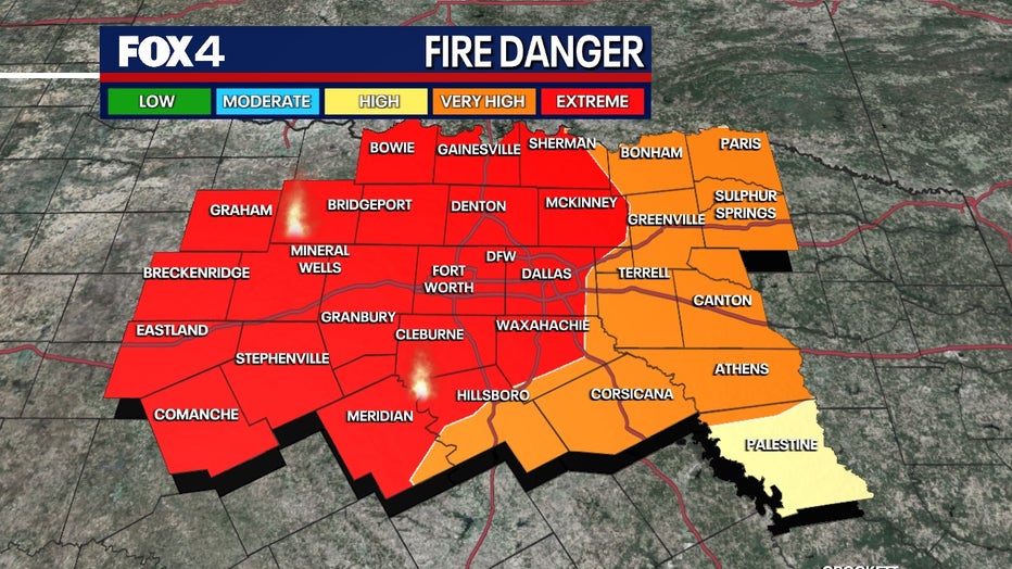
After a briefly cool start, the temperatures will quickly warm up Monday thanks to stronger south winds and mostly sunny skies. Because the air is so dry initially, humidity will remain low today. That will create another high fire risk, especially for areas west of I-35W. Please be careful as any fire will spread quickly.
Gusty winds from the south will continue tonight and get stronger Tuesday as a rather strong late-winter storm heads through the Rockies. Wind gusts could approach 40 mph tomorrow from the south, so wind advisories are likely. They should have a bit more moisture associated with them, so the fire risk should also be a bit lower even as temps remain in the 80s.
As a dry line heads in Tuesday night, we've added a 20% chance of a shower/storm for areas east of Dallas. That would be as Gulf moisture briefly rides into those areas.
Temperature drop this week
Everything gets swept out early Wednesday morning as a strong cold front races down from Oklahoma. This is a cold storm (with snow up in Kansas and Iowa) so temps will struggle here to get out of the 60s on very gusty NW winds, even with mostly sunny skies.
As the winds die off on Wednesday night, the temperatures will fall pretty fast. We could have patchy frost/freezes Thursday AM (40 DFW) away from the cities. Please be aware if you have done some early planting,
Spring officially begins
SPRING officially begins Thursday. It will be a beautiful day...likely our PICK of the week as we expect sunny skies and light winds to push temps back into the upper 60s by afternoon.
Friday will see a return of southerly winds, warmer temps and a low chance for late day-eve storms with the next cold front.
We'll hit the first weekend of spring in typical Texas fashion. On the milder side (behind a weak cold front) on Saturday, with moisture returning along with a chance for storms Sunday. For now, coverage looks fairly low, although we do have the usual model spread with the weekend system as it's still 6-7 days out.
What is a Red Flag Warning?
What It Means:
The National Weather Service issues a Red Flag Warning when conditions are especially dangerous for wildfire growth.
Each region has different criteria for triggering a Red Flag Warning.
A combination of strong winds, low relative humidity, and dry vegetation are all factors when deciding to issue a Red Flag Warning.
What you can do:
The National Weather Service asks people to avoid all outside burning and welding today.
They urge people not to toss lit cigarette butts outside.
If you see a wildfire or a downed power line, please report it by calling 911 or your local fire department.
The Source: Information in this article is from the National Weather Service and FOX 4 Meteorologist Evan Andrews.